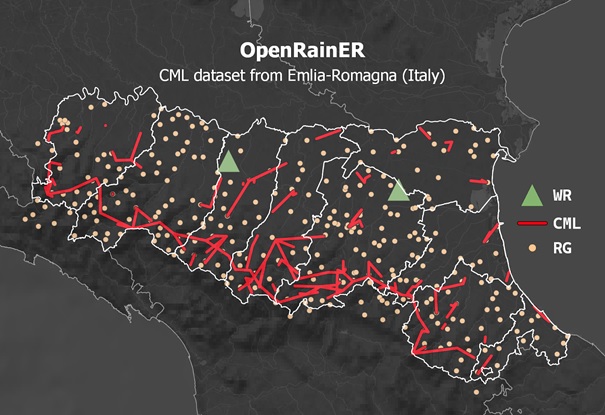
OpenRainER is a newly released open dataset with two years (2021 and 2022) of precipitation-related data from the Emilia-Romagna region in Italy. The dataset contains both conventional and opportunistic sensors, specifically weather radars (WR), rain gauges (RG), and Commercial Microwave Links (CML). This comprehensive dataset presents an excellent opportunity to serve as a benchmark dataset for CML retrieval algorithms and validation techniques over long periods.
The availability of CML data in near real-time in Emilia-Romagna (Italy) is a result of a collaborative effort between the data provider Lepida ScpA, the Hydro-Meteorological and Climate Service of Emilia-Romagna Region (Arpae-SIMC), and the University of Bologna. This collaboration is part of the EU LIFE project CLIMAXPO and the MODMET agreement between Arpae-SIMC and the Italian National Civil Protection Department, ensuring the credibility and reliability of the data.
OpenRainER offers four different products:
- COMMERCIAL MICROWAVE LINKS: 1 min frequency received and transmitted power levels from the Lepida ScpA CML network. The network counts 153 CML active between 2021 and 2022, with carrier frequencies of 24.6 and 25.6 GHz and path lengths ranging from a few hundred meters to 25 km.
- RADAR REFLECTIVITY: Reflectivity composite of the two Emilia-Romagna Region C-band weather radars with a temporal frequency of 5 min.
- GAUGE ADJUSTED RADAR: 15 min radar accumulated rainfall maps, corrected with the information from verified rain gauges, through Ordinary Kriging of the adjustment factor RG/WR.
- WEATHER STATIONS: point measurements of 15 min accumulated rain, temperature, wind speed and direction, and relative humidity (when available).
During these two years, Arpae-SIMC registered rainfall events from both convective and stratiform conditions, with some occurrences of hail and snow. The Emilia-Romagna region is characterised by vast plains just above sea level in the northern part (Po valley) and complex terrain in the Apennines area, with elevations surpassing 2000m on the ridge along the southern border. CMLs from Lepida are primarily located in this area, with many crossing valleys and irregular terrain, posing particularly challenging conditions for reconstructing the rainfall field.
The dataset follows the OpenSense community indications and is released under a Creative Commons license (CC-BY 4.0). Data can be downloaded at https://zenodo.org/doi/10.5281/zenodo.10593848 (Covi, E., & Roversi, G. (2024). OpenRainER (1.0.0). Lepida ScpA, Arpae-SIMC).